FIRST SELF WHO OWNED LAND IN MONROE COUNTY, TN


Recently, after some persistent research, the location of what appears to be the first real estate to be owned by our Self family in Monroe County, Tennessee was discovered. Let me explain.
J.R. Self bought 160 acres on August 1, 1893 for $100.oo from Thos. G. and N.L. Harvey in Monroe County, TN. The deed description is as follows: 160 acres in the Ocoee Land District, 20th Civil District of Monroe County, TN on Turkey Creek, 5th Range, East of Meridian, S.E. quarter of section 35, in 2nd Fractional Township. (W.D. Book 1, pages 384-385)
J.R. Sherman Self was the son of John J. and Lydia Avaline Waters Self. He was born March 19, 1865 and was 28 years old when he purchased this tract of land. Our Self ancestors are believed to have been living in Monroe County for at least 7 years by 1893. J.R. Self sold this land to the Tellico River Lumber Company in 1910 for $800.00 (W.D. Book 15, page 233)
It is interesting to note that J.R. Self's brother, C.C. (Cicero) Self, bought an adjoining 160 acres on June 6, 1900 from W.D. Henderson and W.D. Hale for $75.00. It is described as being in the 20th district, being the north east quarter of section 35, Range 5 East, Fractional Township 2 North, Ocoee Land District, containing 160 acres more or less. C.C. Self sold this property to a William Butler only 6 months after he purchased it. (W.D. Book 6, pages 186-187, W.D. Book 6, page 299.
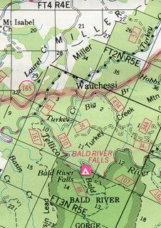
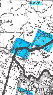
A few months ago I made a visit to the Tellico Ranger Station in Tellico Plains and sought the help of a ranger in pinpointing the exact location of the two aforementioned tracts of land. Using forest service maps, we were able to determine where the properties are located. Plese see the photos of the two maps accompanying this story.
Each square on the maps represents one square mile or 640 acres. Each square mile is divided into four equal quarters or 160 acres. The black and white map shows highlighted in blue section 35 of FT2N R5E in which J.R. Self and C.C. Self each owned 160 acres. Section 3 of FT3N R5E is also highlighted. Oral history accounts state that Cicero Self once lived very close to Miller Chapel Church at Turkey Creek. The specific site on which he supposedly lived lies within section 3. The map shown in color also shows both sections in a little different detail.
The land referenced here is now owned by the federal government. It is forest service property, part of the Cherokee National Forest. The Cherohala Skyway, a beautiful scenic highway, goes through this property, running from Tellico Plains to Robbinsville, North Carolina.
In case anyone asks you where your Self family came to Tennessee from, this would be a correct response. They came from north Georgia, Union and Lumpkin Counties, to Monroe County, Tennessee around 1886 and settled at Turkey Creek in the mountains above Tellico Plains. This is where our Self family first settled in Tennessee. Or at least the research I have done brings me to this conclusion.
C.C. (Cicero) Self bought land in Blount County, TN in 1900, but that is a topic for another story.


<< Home